
February is often the toughest month of winter and this year was no different. It was touch-and-go for a while but I was lucky to survive a bout of man-flu at the start of the month. The time off the bike had undone much of the good work I’d put in since the start of the year though. Then a last-minute space in my calendar opened up and within a few hours I’d lined up another budget weekend vitamin D session; this time in Gran Canaria. God bless EasyJet and Airbnb!
“Dedication to drinking, dietary exuberance and sun worshipping means everybody looks the same. The only difference is the ladies put bikinis over their boobs.”
The Canary Islands are funny old places. The retired Brits and Germans that have made the coastline their home all share an identical look. Years of dedication to drinking, dietary exuberance and sun worshipping means everybody has exactly the same body type. The only difference is the ladies put bikinis over their boobs. Maspalomas, our base for the weekend, is like Las Vegas. A desert wasteland peppered with enormous all-inclusive resorts that guests never need to venture from. We’ve found ourselves a small Airbnb apartment in a little single-storey development surrounding a small pool. When we walk in, carrying our bikes in enormous cardboard boxes and looking 30 years too young, the elderly residents are sunning themselves on the loungers and stare at us with a mixture of confusion and dread. It suits our needs perfectly well though.
Day 1

I’m out here with my buddy, Pops, a film-maker who’s using this to kickstart his year of fitness and bag some cycling footage. He’s right in at the deep end – which is his style – as the biggest ride he’s done so far is 45km and one climb of 125m up Box Hill. There are no flat rides on Gran Canaria so this is going to be a big step up for him whatever he does. We roll together to the foot of the GC-60, the primary road which climbs up to the centre of the island. There are three towns on the way up and he’s targeting at least the first town today. I’ve plotted a route for myself which goes to the top, does a little loop around the crown and then back down to the apartment.

The road is wide and well surfaced. Drivers are polite and patient. The weather is already a glorious 20°C when we set off. The wind is quite spicy though. What was forecast as a 20mph northerly wind actually feels like a southerly tailwind to begin with. That would be very nice for today’s big climb. Whereas Tenerife is a continuous and consistent climb to the single summit, Gran Canaria has many more summits and is much more undulating as a result. You climb a bit; you descend a bit; you climb a bit; you descend a bit. The 2,000m summit hides an enormous amount of sneaky additional climbing in its profile.
“On the short fast descents I’m making ‘meep meep’ noises in my head as I pull away from the chasing cars.”
It isn’t long before that friendly southern wind is replaced by the predicted northerly. It’s pretty gusty too so I’m grateful that it’s a direct headwind and not a crosswind. It doesn’t try to throw you off the road, it just puts its giant hand on your forehead and laughs as you try and make progress. The big barren landscapes make me think of the old Warner Bros Roadrunner and Wile E Coyote cartoons. On the short but fast descents I’m making ‘meep meep’ noises in my head as I pull away from the chasing cars.

Two hours into the climb I pass through the town of San Bartolomé de Tirijana and the road dips violently down. The steepness has caught me a bit by surprise and I’m hard on the brakes trying to shed speed before the tight blind corner ahead. Immediately beyond that corner is a T-junction and with my chest on the saddle and arse right back over the rear wheel I only just manage to hold it all together and stop in time. I’m wide-eyed and awake now. The climb gets prettier from here as I’m making my way up into the tree line, where the moisture that rolls off the mountain feeds the greenery. I pass the town of Ayacata and its two ‘bike stop’ restaurants that act as a hub for riders. It’s onwards and upwards to Pico de las Nieves – the highest point on the island at 1,949m.

At the summit is a military installation with an enormous football-shaped radar. You can see out across the southern half of the island – where I began the ride – and, today at least, all the way across the waters to Teide on Tenerife.


I keep heading north, beginning my counter clockwise loop of the crown and drop 1,000m before I turn to catch the tailwind for my 400m climb back up to Ayacata. The road surfaces are a bit mixed and none of them are as immaculate as the crater road on Tenerife. It’s not wise to really unleash the fury on the descents here as you always want a little margin to cope with any suddenly sketchy surfaces. The curves are constant, tight and often unsighted so I reigned it in a little. Because I’m childish and can’t be trusted I used my old trick of stopping for a photo early in the descent. That ruins any thoughts of attacking the Strava times and getting carried away. On the final short descent back into Ayacata there was a tightening left bend with two skid marks illustrating the Thelma & Louise option, straight through a shiny new barrier and past a snapped tree. Whichever unlucky souls were in that car would’ve had enough time for a big argument before they finally hit something.
The bike stop restaurant was now swamped by cyclists. The food choices aren’t all that inspiring so I limit it to a plate of pasta and then start the descent home. Those sneaky daggers hiding in the profile still managed to catch me by surprise on the way back. The vicious ramp through San Bartolomé was even more savage on the way up. The final sting in the tail is the set of hairpins 10km from the coast. They’re not more than 10-12% but they do drag, especially at the end of a very lumpy day.


Back at the apartment and Pops had done impressively well. He’d climbed 1,500m, which is the same as 12 times up Box Hill. Quite a step up and he’s totally recalibrated what he knows he’s capable of now. Dodging the tourist trap promenade restaurants we jumped in the car for 20 minutes to El Guanchito in Vecindario. Our host described it as ugly but cheap and very good food. He was spot on and we worked our way through pretty much the whole starter menu. I also made a mental note not to wear long-sleeved aero jerseys on winter training camps in the future.
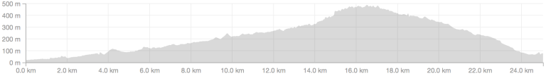
Strava link // Pico de las Nieves // 111km & 4,791m // Relive video
Day 2
Part I
I started the day with the 500m climb up to Palmitos Park, riding together with Pops. The surface here is good and the climb is relatively mellow up to the final kilometre, where it ramps up sharply. We rolled down the steeper descent and then I set off on a longer loop while Pops rode back to freshen up and grab the car to meet me at the top for more filming.


Strava link // Pops does Palmitos // 25km & 900m
Part II

My extra loop ran along the southern coastline heading clockwise before climbing up through Mogan and into the climb known as Serenity, which a friend had told me was a picturesque spot for the filming we had planned. The coast road was a lumpy affair, the scale of the big climbs again masking all the smaller stuff in the profile. Any hopes of a friendly southerly wind again were also dashed, with the wind fighting me head on. The surface was good though and there were lots of large guided groups out on the road to lure me into overtaking and pressing on.

I was meeting Pops at a viewpoint near the top of the climb. He’d driven up a different way so that between us we’d scouted a wide area for the best shooting locations. I was pretty cooked though and that extra headwind had depleted my food supplies. When he arrived we agreed we’d shoot here but I needed to head back down for some lunch first. The descent was a beautiful thing. Very technical but by now I was dialled in properly to the surfaces and it felt great to string the corners together and really ‘flow’ down the mountain.

Lunch at the orange El Draguillo restaurant was amazing. The morcilla sausage is like a sweet black pudding. It doesn’t look all that appealing but damn it’s tasty! We chased that down with Canarian potatoes (boiled with a salty coating) and some grilled fish. Then I jumped in the car and we drove back up to the top to grab some shots. After our late start it was already 5pm and we didn’t have a whole lot of daylight left, but it did mean we were shooting during ‘magic hour’ when the sun is low and makes everything prettier. Traffic was also quieter but still somehow managed to foul half of our shots.


With the light fading and my belly roaring we packed up and decided to grab some dinner locally before driving back to base. I rolled down to Playa Mogán and found a place in the harbour. I needed a big meal as I was planning a whopper of a day tomorrow. My friend Felix had told me I couldn’t leave without riding the Valley of the Tears. Ray from Cycle Gran Canaria offered tips on the route. He’d just ridden it with a group of US customers who all offered the feedback “never again”. Who could refuse a challenge like that?
Strava link // Shooting at Serenity // 78km & 2,800m // Relive video
Day 3

Back along the coastline again, this time towing two local riders as far as Lomo Galeon, before I turned north and began the Soria climb. My friend Rob had visited the island a few weeks ago and warned me off this road on account of the road surface, but Ray and Felix had both recommended it. I figured I’ll climb it but find a different way to descend, when surface quality is more critical. It’s clearly popular with guides as there were several trains of riders out on the climb. It starts off mellow and then ramps up to 7-12% all the way to 670m. Here there’s a little turning off to the left with a sign prohibiting bicycles. My route was plotted up and over and I already knew many others had ridden this so I disregarded it.


Immediately the gradient steepened and the surface turned to shit. The road was very narrow – a single car’s width – and twisted sharply up hairpins to towards the summit. I passed a few cyclists pushing their bikes and one brave fool struggling down the other way. Near the summit I heard a huge commotion behind and dived off the road just as a fleet of jeeps came screeching up the hill as fast as they could manage, full of cheering/screaming punters and shaky cameras. That’ll be why they try and ban bikes up here then.

It was with huge relief that I made the junction at the top and rejoined some rideable tarmac. I was now above the Serenity climbs from yesterday. I stopped just below the top to grab a photo and spoil the Strava segment time, before grinning all the way back down to Mogán. This time I rode straight past the restaurant and straight into the climb eastwards, towards San Nicolás.

I was on the lookout for a petrol station or somewhere I could resupply when I passed another of the island’s bike stops. This was a little market stall with cold drinks and fruit. A papaya-banana-orange smoothie hit the spot. I topped up my bottles with cold water and pressed on. The descent down into San Nicolás was 8km of open roads (which meant fast speeds) but super rough surfaces, which were punishing on the body. Braking is tricky because you’re thrown around a lot and the wheels skip across the surface like a speedboat on the water. The very last thing you want to do is crash because you’ll be grated to the bone on a surface like this. By the time I reached the bottom I was looking forward to the climb, hoping the punishment would be less severe. I was wrong.
“I emerged through a canyon to discover a cliff face with some tarmac clinging to it and watched as a car groaned its way up in first gear.”
The route profile suggested the first 10km of the climb would be gentle, before it got undeniably savage for the last 15km. Yet again the scale of the bigger climbs managed to hide the myriad of smaller climbs on the lower slopes. These were brutal ramps made so much worse by the awful road surface. Valley of the Tears? They must mean ‘sidewall tears’ as I feared for the health of my tyres on this nasty road. I kept checking the elevation screen on my Wahoo ELEMNT to be double sure I was still on the ‘easy’ bit. Yep, sure enough the hard bit was still a long way away. Damn.

I emerged through a canyon to discover a cliff face with some tarmac clinging to it and watched as a car groaned its way up in first gear. Sorry, legs. After much swearing I’d climbed my way to a tight junction where the Valley of the Tears segment begins. It looked horrible and I was already broken from the rough climbing I’d covered to get here. The profile says 10km at 10% but I’d realised by now that it’ll probably include a lot of hidden ups and downs that make the climbing average that much higher.

The first kilometres of hairpins were a punishing 15-25% gradient. On this bike with a semi-compact chainset I needed 300W+ to keep the pedals turning at a knee-popping 50rpm.  I’d love to say it was all the photo opportunities that kept me stopping regularly but the truth was I couldn’t sustain the effort in the heat of the day, with the weekend’s fatigue in my legs. I made a mental note to call Ray and Felix bastards and buried my head for what I suspected would be at least another 90 minutes of this nonsense.
The blazing heat of the day and the punishing effort of the climbing had guzzled up all of my water. My black jersey was now heavily marbled with white salt and I’d smashed my last energy gel 20 minutes ago. The final hour was going to be rough but there was no escape route so I just needed to get it done. The landscapes tried to distract me by being remarkably pretty but, if you’ll excuse the pun, it was an uphill battle. I passed two lads who’d thrown in the towel and were pushing their bikes. I did think back to that mad day in Italy on the TCR where I foolishly climbed 24% slopes instead of walking; doing lots of damage to my achilles in the process. No, it’s OK. I’m stronger now. I have shoes that put my cleats further back to spare my achilles. Still I kept a close monitor on my body to avoid doing any damage.
“I made a mental note to call Ray and Felix bastards and buried my head for what I suspected would be at least another 90 minutes of this nonsense.”


Half way up the Valley of the Tears you emerge onto a spine with dramatic drops on either side. This is pretty enough that you absolutely have to stop and grab a photo. Then a short while later you pass a set of steps on the right, leading up to a shrine and a viewpoint. Obviously that necessitates another stop. For the photo opportunity; you understand?

Finally, mercifully, the road began to shallow off. A bit of descending, chasing a car along the dodgy surface, and then one last climb up to reach the main road and a passable surface once again. By the time I reached Pops at the restaurant in Ayacata the kitchen had closed, so I settled for an ice cream and then we climbed up into the tree line to grab some more drone footage. This time I found it a bit harder doing the climbing laps and trying not to look totally shagged. We were also a bit worried that my salty jersey looked a bit extreme, but it was OK as long as we avoided close-ups.
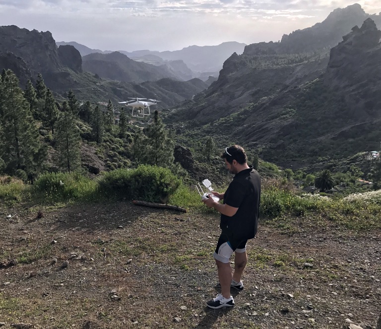
With depleted batteries (mine and the drone’s) I started the long descent back to Maspalomas. It was dark enough for lights and the traffic had all but disappeared so I had an amazing time swooping my way down the mountain. This was only interrupted by the silly climb at San Bartolomé and the final ramps before home. The Relive videos are always great when the rides are very lumpy and this one was particularly watchable. The surface, the heat and the volume of climbing combined to make this one of the hardest rides I’ve done. The post-ride meal was gargantuan in response.
Strava link // Valley of the Tears // 137km & 6,608m // Relive video
How does Gran Canaria compare with Tenerife? There’s much more scope for route variety on Gran Canaria but most of it has pretty rotten surfaces. I think overall it’s perhaps the better option for any visit longer than a weekend, but I’d definitely recommend wider tyres and plenty of electrolytes.


Darren! Hugely enjoyed this – will have to add it to the ever-expanding list of places to ride..
LikeLiked by 1 person
Fantastic Blog Darren. I was there only a couple of weeks ago and rode many of the roads you have documented. I was unaware of your blog until Rob Jordan sent me the link to this blog. I thoroughly enjoyed the rides and variety on Gran Canaria and would certainly return
LikeLike
Thanks for the kind words chaps. Three weeks later and my memories of the riding have taken on a rosier hue. There are some savage routes for a rider in winter shape, but damn it’s pretty out there. I’m sure I’ll be back but, like Tom, I’ve still got a long list of awesome destinations to tick off before I start repeating trips.
LikeLike
Great read, thanks for the write up, Darren. Are any of these stunning photos taking by a phone?! If you do a repeat trip and are inclined to some roads less ridden, I would recommend the east side of the island and use the non-numbered roads to cut between the main roads as much as you dare. Expect awesomely quiet, narrow, steep roads and plenty of random gravel secteurs!
First two days of my trip:
https://www.strava.com/activities/826528905
https://www.strava.com/activities/827530292 (I can’t decide if I love or hate the GC-130 on this day, it was rough tarmac for about 20km uphill)
LikeLike
Thanks for the tip Felix. I’ll definitely be back but I may not be in a huge rush to find random gravel secteurs.
All of the shots here were taken on my iPhone. I’d love to have had my SLR with me but I’m carrying enough climbing ballast already!
LikeLike
Hi Darren, the photos are amazing yet they were taken on an iPhone? Do you use editing software to get the colors so magical? My photos of this ride were much more drab 😦
LikeLike
I use Snapseed on some shots, particularly low-light shots. The iPhone copes fairly well in bright sunny conditions but all digital photos can benefit from some sharpening as the final step. People can be heavy-handed with sharpening though. There are other photography tricks too. Shooting with the sun behind you helps to saturate colours.
LikeLike
I’ve just had another look at those photos and I have to take it all back. There’s some very clumsy HDR filter applied to most of these! You can tell it’s overdone when there’s ghosting between the light and dark areas.
LikeLike
Well I liked the photos enough that I used one of them on my web site 🙂 I did credit you. Hope that’s okay. The page is https://contributingtotheproblem.com/cycling-2/gran-canaria/ Credit at the bottom of the page. Your ride was a lot more impressive than mine though!
LikeLike
Sorry that’s an old link. This is the correct one:
https://contributingtotheproblem.com/cycling-2/cycling-in-spain/gran-canaria/
LikeLike
Wonderful write- up! I do wish my knee would allow some riding!
LikeLiked by 1 person
Really enjoyed reading this – I must try to treat myself to something like this, so long as my body could manage those climbs! Most of my riding is done on the flat, so mountains are a bit of an unknown to me and my legs. Fabulous Relive vids and photos, too – thanks for writing this up.
LikeLiked by 1 person
Maybe save the Valley of the Tears for a second trip. That’s one of the toughest climbs in the world and could put you off for life. On the other hand, once you’ve tackled that there’s very little that ultra-race organisers could throw at you that would seem impossible.
LikeLiked by 1 person
Indeed, I agree. I’m pretty sure I’d stay well away from that climb and tackle some of the less demanding terrain that GC has to offer.
LikeLike
Serenity is up there with the best in the world.
LikeLiked by 1 person
Thanks for the very amusing blog Darren . Particularly liked the “ rock face with a bit of tarmac clinging to it “ or words to that effect . Am off to G C for 3 months in December , largely due to your comments . Am getting a compact slapped on before then but only have an 11/30 on the back – what do you reckon ? .( I’m 70 , 12 stone 4 , 5ft. 10 and new to biking but did the Rocacorba ( Girona area ) last week( from the start line on the bridge ) in 55 mins 56 secs on a semi compact 11/30 . Meep meep . Serenity now ( Seinfeld ) !
LikeLike
3 months! That’s how you do winter properly! You’ll know every climb on the island by spring.
It sounds like you’ll be fine on that setup. Everybody arrives at the Valley of the Tears under-geared, so that’s always going to be a struggle, but that’s the extreme. That’s a good setup for everything else. I’d still recommend the widest tyres you can fit as the road surfaces are very rough.
LikeLike
Thanks for the prompt reply Darren . Will get some 28’s on the wheels . Serenity now , more serenity in Dec.
LikeLiked by 1 person